
Duration
22 Days
Difficulty
Moderate-Hard
Location
"Kanchenjunga Region"
Max. Altitude
5,150 m
Best Season
Spring (March-May) and Autumn (September-November)
Accommodation
Hotel and lodges / local tea houses
Meals
During Trekking (Breakfast, lunch & dinner)
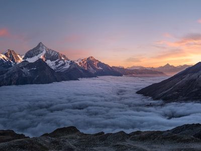
The Kanchenjunga Base Camp Trek is one of Nepal’s most remote and challenging Himalayan adventures, taking you to the base of Mount Kanchenjunga (8,586 m), the world’s third-highest peak. This extraordinary journey offers stunning views of Kanchenjunga, Jannu Himal, and surrounding peaks while crossing diverse landscapes, from lush forests and deep valleys to rugged alpine terrain and high mountain passes like Sele La. The trek covers both the North Base Camp at Lhonak and the South Base Camp at Ramche, making it a complete and rewarding circuit experience.
The trek starts with a flight or drive from Kathmandu to Bhadrapur, followed by a scenic drive to Taplejung, the gateway to the region. Accommodation is in simple teahouses and local lodges along the route, offering an authentic mountain experience. An experienced trekking guide and porter support are provided for safety, navigation, and comfort. All necessary permits for the Kanchenjunga Conservation Area are included, along with meals during the trek and basic emergency support. This itinerary is fully customizable, allowing trekkers to adjust the route and pace based on preference and fitness. It is an ideal choice for adventure seekers looking for a less crowded, truly remote, and unforgettable Himalayan trekking experience.
Leaving Lhonak (4,780 m), the trail begins a long descent back towards the lush alpine valley as you retrace your steps through the dramatic high Himalayan landscape of the Kanchenjunga region. The route follows rocky moraine, glacial valleys, and river-fed paths, gradually transitioning from barren high-altitude terrain to greener slopes as you lose elevation. Along the way, you pass through Khambachen and surrounding wilderness sections with stunning views of Jannu Himal and the distant snow-capped peaks. The journey continues steadily downhill until you reach the traditional Sherpa village of Ghunsa (3,415 m), where forests and settlements return after the high alpine zone. The trek takes approximately 7–8 hours, covering around 20–22 km, with an elevation loss of about 1,365 m.
Departure from Kathmandu marks the end of your Kanchenjunga Base Camp Trek adventure. As per the flight schedule, our representative will transfer you to Tribhuvan International Airport, ensuring a smooth and comfortable departure process. You will leave Nepal with unforgettable memories of remote Himalayan landscapes, rich cultural experiences, and a truly extraordinary trekking journey.
A rest day in Kathmandu (1,400 m) is dedicated to relaxation, recovery, and personal exploration after completing the Kanchenjunga trekking adventure. This day allows you to rest your body, enjoy leisure time, and explore the vibrant streets of the Kathmandu Valley at your own pace. You may also go for shopping in Thamel for souvenirs, trekking gear, and local handicrafts, or simply unwind at your hotel. This recovery day helps you regain energy while experiencing the cultural atmosphere of the capital before departure.
Fly from Bhadrapur (91 m) to Kathmandu (1,400 m) in approximately 45 minutes, covering an aerial distance of around 520 km. This scenic flight offers a beautiful transition from the flat lowland Terai region back to the Kathmandu Valley, with occasional views of green hills and distant Himalayan peaks on clear days. The journey involves a rapid elevation gain of about 1,309 m, providing a comfortable and time-saving connection to the capital after completing the trekking adventure.
Driving from Ilam (1,200 m) to Bhadrapur (91 m), the journey descends from the cool tea-covered hills of eastern Nepal into the warm lowland Terai region. The route passes through scenic tea gardens, rolling green hills, small towns, and rural settlements, gradually transitioning from mountainous landscapes to flat plains. As you approach Bhadrapur, the air becomes warmer and the surroundings more tropical, marking the end of the hill journey. The drive takes approximately 4–5 hours, covering around 90–100 km, with an elevation loss of about 1,109 m.
Leaving Yamphudin (2,080 m), the journey continues with a scenic and adventurous off-road drive towards Ilam as you gradually descend from the remote highlands into the lush eastern hills of Nepal. The route passes through winding mountain roads, terraced farmlands, forested ridges, and small rural settlements, offering beautiful views of rolling hills and distant valleys along the way. As you lose altitude, the landscape becomes greener and more developed, eventually reaching the charming tea-growing district of Ilam (1,200 m). The drive takes approximately 7–8 hours, covering around 120–140 km, with an elevation loss of about 880 m.
From Tortong (2,995 m), the trail begins a long and steady descent into lower elevations as you follow the Simbuwa River valley through dense rhododendron, bamboo, and mixed forests. The path winds through peaceful wilderness sections, crossing small streams and traditional forest trails, gradually transitioning from alpine terrain to subtropical vegetation. Along the way, the landscape becomes increasingly green and vibrant as you approach inhabited areas of the lower valley. The day’s journey ends at the culturally rich village of Yamphudin (2,080 m), a welcoming settlement surrounded by terraced hills and farmland. The trek takes approximately 6–7 hours, covering around 14–16 km, with an elevation loss of about 915 m.
Leaving Cheram (3,870 m), the trail descends steadily through the scenic Simbuwa Valley as you gradually move away from the high alpine environment into greener and more forested landscapes. The route passes alongside glacial streams, rhododendron and pine forests, and rocky mountain paths, offering peaceful views of waterfalls and distant Himalayan peaks along the way. As the altitude decreases, the surroundings become increasingly lush and the air noticeably warmer, leading you down to the tranquil settlement of Tortong (2,995 m). The trek takes approximately 5–6 hours, covering around 10–12 km, with an elevation loss of about 875 m.
Starting from Cheram (3,870 m), the trail ascends gradually through the scenic Simbuwa Valley, passing alpine meadows, glacial streams, and rugged mountain terrain as you move closer to the southern face of Kanchenjunga. The route steadily climbs towards Ramche (4,580 m), offering spectacular views of Yalung Glacier and surrounding snow-capped peaks. From Ramche, a short hike continues further to Kanchenjunga South Base Camp (4,730 m), where dramatic icefalls and towering Himalayan walls create an unforgettable high-altitude panorama. After spending time at the base camp, the journey retraces back to Ramche and continues down to Cheram. The trek takes approximately 6–7 hours, covering around 12–14 km in total, with an elevation gain of about 860 m and a return descent of 860 m.
After leaving Sele Le Base Camp (4,200 m), the trail enters one of the most challenging and scenic sections of the trek as you ascend towards the high mountain pass. The route climbs steeply through rugged alpine terrain, rocky ridges, and exposed sections marked by prayer flags, offering incredible panoramic views of Kanchenjunga, Jannu Himal, and the surrounding Himalayan valleys. After crossing the pass, the landscape changes dramatically as you begin a long descent through remote highlands, alpine meadows, and forested trails. The journey gradually leads down into the lush Simbuwa Valley, eventually reaching the peaceful village of Cheram (3,870 m). The trek takes approximately 7–8 hours, covering around 15–16 km with significant elevation gain and loss throughout the day.
Starting from Ghunsa (3,415 m), the trail climbs steadily into a remote and less-traveled alpine route as you leave the main valley behind and begin the ascent towards Sele Le Base Camp. The path passes through dense rhododendron and pine forests, gradually opening into rugged high-altitude terrain with increasingly wide views of the Kanchenjunga range and surrounding peaks. As you gain elevation, the air becomes cooler and thinner, and the landscape shifts to a more exposed ridge environment before reaching the isolated setting of Sele Le Base Camp (4,200 m). The trek takes approximately 6–7 hours, covering around 12–14 km, with an elevation gain of about 785 m.
Upon your arrival at Tribhuvan International Airport, our representative will pick you up and transfer you to the hotel. Rest of the day is free for relaxation and recovery after your journey.
Today begins from Lhonak (4,780 m) as you set out on the most remarkable day of the trek towards Kanchenjunga North Base Camp. The trail gradually crosses rugged glacial moraine, rocky high-altitude terrain, and vast open landscapes shaped by ancient ice flows, with dramatic views of towering peaks and surrounding Himalayan wilderness throughout the journey. As you approach Pangpema (5,150 m), the North Base Camp of Mount Kanchenjunga, the scenery expands into a breathtaking amphitheater of glaciers, icefalls, and snow-covered mountains. After spending time at the base camp, you retrace your steps back to Lhonak. The trek takes approximately 6–7 hours, covering around 14–16 km in total, with an elevation gain of about 370 m.
After breakfast at Khambachen (4,050 m), the trek begins as the trail steadily ascends into a dramatic high-altitude landscape, moving closer to the Kanchenjunga glacier region. The route passes through rocky moraines, glacial valleys, and sparse alpine terrain, with stunning views of Jannu Himal and surrounding snow-capped peaks dominating the horizon. As the altitude increases, the environment becomes more rugged and remote, following the river carved by ancient glaciers through a vast Himalayan wilderness. The trail gradually leads to the isolated settlement of Lhonak (4,780 m), one of the highest camping points of the trek, offering breathtaking panoramic mountain scenery. The trek takes approximately 5–6 hours, covering around 10–11 km, with an elevation gain of about 730 m.
Starting from Ghunsa (3,415 m), the trail gradually ascends into a more rugged and alpine environment as you continue deeper into the Kanchenjunga region. The route follows the Ghunsa River valley, passing through pine forests, rocky terrain, and glacial-fed streams, with increasingly dramatic views of snow-covered peaks and hanging glaciers along the way. The landscape becomes more remote and exposed as you gain altitude, offering a true high-Himalayan trekking experience before reaching the quiet settlement of Khambachen (4,050 m). The trek takes approximately 5–6 hours, covering around 10–12 km, with an elevation gain of about 635 m.
A well-planned acclimatization day is spent at Ghunsa (3,415 m) to allow the body to adjust safely to the increasing altitude before heading further into the high Himalayas. The day includes a relaxed pace with a short guided hike to nearby viewpoints and surrounding ridges, offering stunning views of the Kanchenjunga range and the deep Ghunsa valley. This active rest day also provides an opportunity to explore the traditional Sherpa village, interact with locals, and experience the unique mountain culture of the region. The remaining time is used for rest, hydration, and preparation for the upcoming higher altitude trekking sections.
Leaving Gyabla (2,730 m), the trail gradually climbs higher into the alpine zone as you follow the Ghunsa River valley through dense pine and rhododendron forests, quiet wilderness paths, and occasional wooden bridges. The scenery becomes more open and dramatic with every step, revealing distant snow peaks and rugged mountain landscapes that define the Kanchenjunga region. Passing through remote stretches of untouched nature, the route steadily ascends until you arrive at the beautiful Sherpa village of Ghunsa (3,415 m), one of the most important settlements in the area. The trek takes approximately 5–6 hours, covering around 12–14 km, with an elevation gain of about 685 m.
After breakfast, begin the trek from Amjilosa (2,490 m), the trail continues through dense bamboo and rhododendron forests, gradually ascending along the Ghunsa River valley with occasional steep and narrow sections. The route offers a peaceful wilderness experience with small waterfalls, wooden bridges, and chances to observe local flora and fauna as you move deeper into the Kanchenjunga region. The landscape slowly opens up as you approach the higher settlement of Gyabla (2,730 m), where the terrain becomes more alpine and the air noticeably cooler. The trek takes approximately 5–6 hours, covering around 8–10 km, with an elevation gain of about 240 m.
Starting the trek from Sekathum (1,650 m), the trail climbs steadily along the Ghunsa River valley through dense forests, rocky paths, and beautiful waterfalls, offering a true introduction to the remote landscapes of the Kanchenjunga region. The route involves multiple suspension bridge crossings and gradual uphill sections as you pass through small settlements and untouched natural scenery, with the environment becoming increasingly alpine as you gain altitude. The day’s journey concludes at the peaceful mountain village of Amjilosa (2,490 m), after approximately 6–7 hours of trekking covering around 10–12 km, with an elevation gain of about 840 m.
Today marks the journey deeper into the Kanchenjunga region as you leave Taplejung and drive towards Sekathum, entering more remote and untouched Himalayan landscapes. The road gradually descends through lush green hills, river valleys, and small traditional settlements, offering beautiful views of the eastern mountains along the way, with off-road sections, suspension bridges, and winding mountain tracks providing a true taste of rural Himalayan travel before the trekking begins. Drive from Taplejung (1,820 m) to Sekathum (1,650 m) takes approximately 6–7 hours covering around 45 km, with an altitude loss of about 170 m throughout the journey.
The journey begins with a flight from Kathmandu (1,400 m) to Bhadrapur (91 m), taking around 45 minutes and covering an aerial distance of approximately 520 km, offering a quick transition from the capital to the eastern lowlands of Nepal. Upon landing, the trip continues with a 7–8 hour scenic drive from Bhadrapur to Taplejung (1,820 m), covering about 120 km through winding hill roads, tea plantations, river valleys, and rural settlements. This day involves a total altitude change of 1,309 m descent followed by a steady 1,729 m ascent, gradually leading you into the remote mountain region of eastern Nepal.
Today you will enjoy a guided sightseeing tour of UNESCO World Heritage Sites in Kathmandu Valley, including Boudhanath Stupa, Pashupatinath Temple, Kathmandu Durbar Square, and Swayambhunath Stupa. After the sightseeing, there will be a detailed guided trek briefing where your trekking guide will explain the route, safety guidelines, and preparation details. All necessary permits will also be arranged on this day to ensure a smooth and well-organized trekking experience.
The Kanchenjunga trekking package can be customised to suit your preferences, including itinerary, duration, budget, and comfort level, ensuring a flexible and personalized travel experience.
No economic inclusions specified.
No deluxe inclusions specified.
No economic exclusions specified.
No deluxe exclusions specified.
No economic pricing available.
No deluxe pricing available.
Be the first to share your experience!

No FAQs available.
Our Travel Experts
Chat directly with our team for personalized recommendations and group discounts.

David M.
Senior Guide

Sarah C.
Trek Expert

Michael T.
Support Lead
We're proud to have helped countless adventurers create memories that last a lifetime. Read their stories of discovery, trust, and joy, and see why we're the go-to choice for travelers worldwide. Your next adventure could be your best one yet just like it was for them.